

Triglavski narodni park (TNP) is located in the area of the Julijske Alpe. The park is the only national park in Slovenia and follows a special nature protection regime, which is stricter than in landscape parks. High-mountain karst predominates in the park area. The flora is typically alpine, but due to the proximity of the Adriatic Sea and the influence of the Mediterranean climate in the southwestern part, plants from that region are also present.
Naming
Triglavski narodni park is named after the highest Slovenian mountain, Triglav, which lies in the central area of the park.
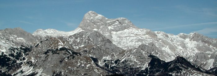
Triglav (2,864 m)
Short description of hydrology in TNP
There are two major watersheds in Triglavski narodni park: the Soča river, flowing into the Jadransko morje, and the Sava river, flowing towards the Črno morje. On the mostly rugged terrain of the mountain karst, numerous permanent waterfalls are also worth noting. Waterfalls are more numerous in the Posočje part of the park.
Soča
Between Mangrt (2,679 m) and Jalovec (2,645 m), the Loška Koritnica springs. Its tributaries have an extremely rugged bed with many waterfalls. Predilnica is a right tributary of Koritnica. Its highest waterfall is the over 50 m high Predelski slap. Also notable for their height are Zaročenca (30 m) and Poševni slap (20 m). Fratarica is a left tributary of Koritnica, springing under Oblica (2,246 m).
The stream covers as much as 1,000 m of elevation difference over its short path. The highest waterfall is the three-stage Veliki Drsnik (112 m). In the Dolina Loške Koritnice, the Skok (Parabola; 48m) waterfall is easily accessible. In the lower course, Koritnica receives a strong right tributary - the Možnica stream (old name Nemčlja). Interesting are its troughs and the 18 m high Veliki Možniški slap, which falls under a natural bridge. The Koritnica river carves its path through a 1 km long canyon between Rombon and Vrh Krnice, with its 60 m deep troughs best seen from the bridge at the Kluže fortress.
In 1981, the extremely picturesque Dolina Trenta was included in the park. Through the Zapoden valley flows the Suhi potok. In its upper course is the officially highest permanent waterfall of Triglavski narodni park: Slap pod planino Zapotok (121 m). Near the confluence with Soča, at an altitude of 1,050 m, the Soča river originates in one of the most beautiful karst springs. As a curiosity: the old name for Soča in the upper course between the spring and the settlement (Trenta) Na Logu was Šnita.
The left tributary Mlinarica is known for its deep troughs (korita). Access to the lower 8 m waterfall is touristically arranged. Nearby is the Alpski botanični vrt Juliana. Above the settlement (Trenta) Na Logu rises the steep Kloma gorge with a 200 m high cascade. East of Na Logu, the Krajcarica flows into Soča through the Zadnjica valley. In lower Trenta, Soča flows through Mala korita, joined by the Vrsnik stream, which has carved interesting 150 m long and 15 m deep troughs.
A popular starting point for Krnsko jezero and Krn (2,244 m) is from Dolina Lepene. The Lepenca stream springs under Debeljak. Its left tributary is Šumnik (Šunik), which has an extremely strong permanent flow and descends in numerous waterfalls. The headwaters of Tolminka and Zadlaščica, known for their deep troughs, hide several 'unknown' streams like Pščak and a unique 20 m high spiralasti slap in the Jelovšček ravine.
Sava
From below Črno jezero, the Savica river emerges 500 m lower in the 78 m high Slap Savice. It continues its path into the glacial Bohinjsko jezero and then as the Jezernica river. North of the lake is the picturesque Dolina Voje, through which Mostnica flows. It is better known for its troughs (korita) than its waterfalls. The Radovna river flows through the famous Blejski vintgar (Vintgar), ending with the magnificent 13 m high Slap Šum.
In Tamar, beneath the walls of Ponce, the Nadiža springs. It rushes towards the valley, disappears, and reappears in Zelenci as the source of the Sava Dolinka. The most attractive waterfall in Tamar is Črna voda (70 m). The parallel Dolina Male Pišnice features a 30 m high waterfall, while under the Vršič road flows Suha Pišnica with the 40 m Slap v Hudičevem žlebu.
Below the Martuljek mountain group, the Martuljek stream descends in a 100 m high 4-stage waterfall. Standing as a guard of Dolina Vrat is the 52 m high Slap Peričnik. In the nearby Dolina Kot, the Kotarica stream forms interesting Slapovi v Kotu before disappearing under the gravel.
Lakes (Jezera)
The largest lake in Triglavski narodni park is Bohinjsko jezero, which is of tectonic-glacial origin. Also well known are the smaller Triglavska jezera, including Črno jezero. High in the mountains are also Kriška jezera and Krnsko jezero.
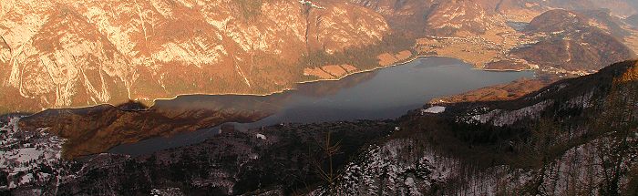
Bohinjsko jezero
See also: List of documented locations
- Waterfalls of TNP
- Triglav
- Triglav Glacier
- Bohinjsko jezero
- Črno jezero
- Dvojno jezero
- Dolina Vrata
- Dolina Trenta
Author: Boštjan Burger, 1998 (1999)