MojaSlovenija.si |
|
|
Soča River (Isonzo) from source to mouthThe Soča River originates in northwestern Slovenia from a karst spring at the foot of Travnik in the Mangrt–Jalovec mountain range in the Julian Alps. The river is 139 kilometers long and flows south of Trieste into the Gulf of Trieste. The Soča runs for 96 kilometers through the territory of the Republic of Slovenia and 43 kilometers through the territory of the Republic of Italy. The source of the Soča River lies at an elevation of approximately 990 meters, at the foot of Travnik in the Mangrt–Jalovec massif, within Triglav National Park. It is a karst spring, where waters collected from the area of Jalovec, Šite, Travnik, and Mojstrovka converge in an underground pool and then emerge through a narrow gorge. 
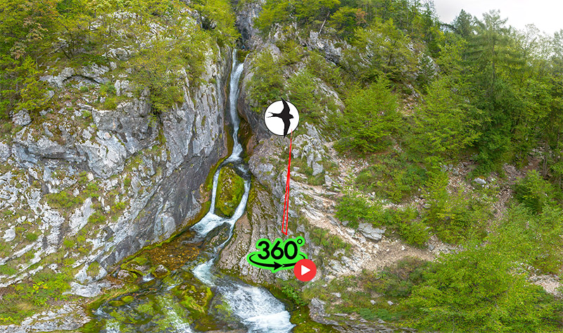
The water that surfaces is exceptionally pure and turquoise-blue, giving the Soča its distinctive emerald appearance. Shortly after the source, the river descends over steep rapids and a small waterfall, creating a dynamic flow typical of alpine rivers. Access to the source is possible via a marked trail from the Koča pri izviru Soče mountain hut, which requires some agility and appropriate footwear, as the upper part of the path is secured with pegs and steel cables. Due to its difficulty, the visit is not recommended for young children or elderly visitors. The Soča Trail also begins at the source—a 20-kilometer-long educational walking path that leads through the Trenta Valley and offers visitors insight into the natural and cultural features of the area. The Small Soča Gorge (Mala korita Soče) is located in the upper part of the Trenta Valley, just before the confluence of the Soča River with the Vrsnica stream. It is an exceptionally picturesque natural phenomenon where the Soča has carved a narrow, deep channel into the limestone bedrock. The gorge is approximately 100 meters long, only one meter wide at its narrowest point, and up to six meters deep. Here, the water flows through smoothly polished rock walls shaped by millennia of erosion. Pools, cascades, and rocky ledges have formed, shimmering in the Soča’s characteristic emerald hue. Due to its compactness and accessibility, the Small Gorge is a popular spot for visitors who wish to experience the river’s power and elegance in a confined space. Access to the gorge is possible on foot via the Soča Trail, which leads from the river’s source toward Bovec. The gorge is also visible from the road bridge connecting Trenta with Bovec. Nearby, there is a tourist farm, a campsite, and an information point of Triglav National Park, offering a pleasant starting point for exploring the valley. Due to the area's protected status, swimming and descending into the gorge are strictly prohibited. Near the village of Soča, the river receives its left tributary, the Lepena, and before reaching Bovec, it is joined by the right tributary, the Koritnica. In this section, the Soča flows through deep evorsion channels. The Great Soča Gorge/Great Evrosion channels (Velika korita Soče) is a 750-meter-long and up to 15-meter-deep evorsion channel carved by the Soča River into solid limestone. It is an outstanding example of fluvial erosion in an alpine karst environment. Located near the village of Soča within Triglav National Park, the Great Gorge represents one of the finest examples of river erosion in Slovenia. Over millennia, the Soča has incised its channel into Triassic limestone, characteristic of the Julian Alps. This type of rock is highly resistant yet susceptible to chemical dissolution, enabling the formation of karst features such as gorges, canyons, and caves. The gorge was formed through prolonged action of water carrying sand and gravel. These particles acted as abrasives, gradually deepening and widening the riverbed. Through a combination of mechanical and chemical erosion, the water sculpted a narrow, winding canyon that is only 2 meters wide in places, while expanding to 8 meters in others. During dry periods, the water level in the gorge is about 3 meters high, but during heavy rainfall or snowmelt, the gorge often fills completely or even overflows its banks. The limestone in this area belongs to the Dinaric carbonate platform, which formed in a shallow tropical sea around 200 million years ago. The gorge is a significant example of geomorphological development in a high-altitude karst landscape, where water activity and tectonics intertwine. Due to its shape and accessibility, the Great Soča Gorge also serves as a natural classroom for studying fluvial processes and karst relief. Visitors can view the gorge from a marked footpath that runs along the left bank of the Soča. Because of its natural value, the area is part of the protected Triglav National Park, and it is important that visitors respect nature and stay on designated trails. From Bovec to Žaga, the Soča River winds through a narrow valley nestled between the steep slopes of Mount Kanin and Mount Rombon. This section is one of the most dynamic and picturesque parts of the river, where emerald waters intertwine with white limestone rocks, rapids, and pools. Geologically, the area is composed of Triassic limestone, which the Soča has shaped over millennia through intense fluvial erosion. This part of the river is a hub for adrenaline-pumping water sports: Rafting: The most popular activity, suitable for both beginners and experienced adventurers. Organized tours typically last around three hours. Kayaking: The Soča is a world-renowned kayaking destination, offering routes of varying difficulty levels. Canyoning: In nearby tributaries such as the Sušec stream, guided descents through waterfalls and natural slides are available. In the summer of 2007, the Soča Valley became a filming location for The Chronicles of Narnia: Prince Caspian. Director Andrew Adamson chose the confluence of the Soča and Gljun streams as the setting for an epic battle in the fictional land of Beruna. For the production, a wooden bridge was constructed, which was removed after filming to preserve the natural environment. The film showcased the pristine beauty of the Slovenian Alps to a global audience, further cementing the Soča Valley’s reputation as a premier destination for both natural and cultural experiences. The Soča River between Srpenica and Trnovo ob Soči is one of the wildest and most scenic sections of the river, renowned for its emerald color, rapids, and deep pools—ideal for water sports and nature appreciation. This stretch of the Soča flows through a narrow valley between the steep slopes of the Krn mountain range and represents one of the river’s most dynamic segments. After a calmer flow through the Bovec basin, the Soča begins to descend into a deeper channel near Srpenica, where the terrain narrows and the current becomes faster and more turbulent. Rapids and Pools: Between Srpenica and Trnovo ob Soči, wild rapids (classified II–IV on the international difficulty scale) alternate with deep emerald pools, characteristic of the karst landscape. Geological Substrate: The river flows over Triassic limestone and dolomite, which are susceptible to erosion and form dramatic rock formations, gorges, and natural bridges. Biodiversity: This section is home to native fish species such as the marble trout (Salmo marmoratus), as well as grayling and the bullhead. The stretch between Srpenica and Trnovo is popular among water sports enthusiasts:
Natura 2000: The entire upper course of the Soča, including the section between Srpenica and Trnovo, is part of the European Natura 2000 conservation network. Cultural Heritage: Near Trnovo lies the homestead of poet Simon Gregorčič, who praised the Soča as the “beautiful, clear daughter of the mountains”—a verse that has become a symbol of the river and Slovenian nature. The Soča River between Trnovo and Kobarid winds through a narrow gorge carved into the limestone bedrock. This section is approximately five kilometers long and is known for its rugged terrain. The water here is fast, frothy, and crashes violently against the rocks scattered throughout the riverbed. The channel is filled with natural ledges, pools, and rapids that alternate with calmer stretches. One of the most notable natural formations is the Otona pool, located roughly halfway between Trnovo and Kobarid. This pool is renowned for its depth, emerald color, and tranquil atmosphere, which contrasts beautifully with the wild rapids before and after it. Near Kobarid, just below the Napoleon Bridge, the Soča narrows into a tight gorge, forming picturesque channels with its signature emerald hue. These channels were shaped by the long-term erosion of the limestone substrate. They are deep, with vertical walls and smooth rocks sculpted by the river over centuries. During low water levels, the water is crystal clear, allowing a view into underwater formations—stone arches, pools, and rapids. The Napoleon Bridge near Kobarid is a stone arch bridge that crosses the Soča River east of the town center. The original bridge at this location was a wooden Venetian bridge, destroyed in 1616. In 1750, a stone bridge was built, over which French troops marched during Napoleon’s campaigns—hence the name. During World War I, Austrian forces blew up the bridge, and after the war, the Italians constructed the current stone bridge. The bridge is approximately 20 meters long and 8 meters wide. Its location is strategic: it connects the left and right banks of the Soča at the narrowest part of the gorge, where the river makes its final constriction before spreading into the Kobarid basin. The Soča River between Kobarid and Tolmin flows through a relatively wide valley, where its current gradually calms after the wilder upper sections. This part of the river lacks pronounced gorges and instead expands into a broader channel bordered by meadows, forest edges, and gravel banks. The water retains its characteristic emerald color, especially in deeper pools that form between natural rock ledges. Downstream from Kobarid, the Soča passes villages such as Kamno, Volarje, Ladra, and Čezsoča, continuing to Tolmin, where it merges with the Tolminka River. The riverbed in this section is generally wide, with occasional rapids and gravel deposits. The flow is gentler, allowing for recreational activities such as fishing, swimming, and kayaking. Pools near Volarje and Kamno are popular summer spots, offering accessible and clean water. Ecologically, this section is rich in aquatic life—home to the marble trout, grayling, brown trout, and rainbow trout. Due to its high oxygen content and purity, the river is suitable for sensitive species. Aquatic vegetation is limited to the river’s margins, where macrophyte algae and aquatic mosses thrive. Geologically, the Soča flows over a limestone substrate that is part of the Julian carbonate formations. The water is carbonate-hard, which affects its chemical composition. Eroded terraces along the river reflect historical fluctuations in water levels. This stretch of the Soča marks the transition from a mountain river to a pre-Alpine one. Although it no longer features the wild gorges found upstream, it retains exceptional aesthetic value, purity, and biodiversity, making it important both for conservation and recreation. Most na Soči lies at the confluence of the Soča and Idrijca rivers, in the heart of the Lower Soča Valley. It is here that the Soča expands into an artificial lake, created by damming the river to serve the Doblar hydroelectric power plant. The lake stretches toward Tolmin and is one of the largest reservoirs in Slovenia. Its calm surface and distinctive emerald color make it especially attractive to visitors. The lake was formed in the 1930s and today serves multiple purposes:
The lake’s tranquil surface reflects the surrounding hills and forests, creating an almost fairytale-like setting. During the summer months, it is a popular spot for relaxation and recreation. The Most na Soči area offers many opportunities for active leisure:
Most na Soči is also known for its rich archaeological heritage. Numerous Iron Age remains have been discovered in the area, attesting to the long history of settlement. The town features an archaeological museum showcasing finds from the Hallstatt culture. In addition, Most na Soči is an important stop on the Bohinj railway line, which connects the Gorenjska and Primorska regions. The car train through the tunnel to Bohinjska Bistrica offers easy access for tourists. At Most na Soči, the character of the river changes—from a wild alpine stream to a calm water surface that enables diverse activities and attracts visitors from all over the world. As the Soča River approaches Gorizia, it transitions from its alpine character into a calmer flow, marking the shift from the hilly Soča Valley to the flat plains of Friuli. In this section, the river winds between the steep slopes of Sabotin and Sveta Gora, while retaining its distinctive emerald color that defines its entire course. Natural setting: Before reaching Gorizia, the Soča flows through a narrow valley surrounded by vineyard-covered hills and forests, creating a remarkably scenic landscape. Historical significance: The area was the site of intense battles during World War I, especially on Sabotin, which rises above the river and is now arranged as an open-air museum. The Solkan Railway Bridge is one of the most iconic bridges in Slovenia and a unique structure on a global scale:
Today, the bridge remains in active use, with trains still crossing it—adding to its value not only as a historical monument but also as a living piece of infrastructure. The clear waters of the Soča River are crystal-clear and turquoise-blue. Due to its location—flowing through a valley open toward the Adriatic Sea—the climate along the Soča is mild both in spring and late summer. Near Gorizia, the river enters the eastern edge of the Northern Italian Plain, flowing through Italy in its final quarter and carrying large amounts of sediment into the Adriatic Sea. Here, the Soča forms a wide gravelly torrent bed typical of the region, which shifts with each high water event and requires long bridges to span. In summer, the riverbed is often nearly dry. In Latin, the Soča was known as Sontius and was, according to some sources, a tributary of the Cold River (Fl. Frigidus), believed to be today’s Vipava River. There is also a theory that the Cold River (Frigidus) was actually the Soča itself. This is supported by the river’s name and the “extraordinary cold” mentioned by Claudian, since the Vipava, as a lowland river, is not particularly cold. It’s possible that Roman geographers already disagreed about the main course: Herodian describes a river—without naming it—as “great and excellent, fed especially in spring and summer by Alpine snowmelt,” which does not apply to the Vipava. On the other hand, Castra ad Fluvium Frigidus was likely near Ajdovščina, and the Battle of the Frigidus in 394 is historically and geographically placed between Ajdovščina and Vipava. From an archaeoclimatic perspective, it is plausible that the lower course of the Soča was not yet a torrent in Roman times. The Tabula Peutingeriana (a 13th-century copy of a Roman illustrated map of ancient roads) depicts the river’s mouth as a large lagoon, not—as today—directly into the Gulf of Trieste. At that time, the Vipava may also have been richer in water, fed by numerous cold karst springs. The Foce dell’Isonzo Nature Reserve (Soča River Estuary) is one of the most important wetlands in northern Italy, combining exceptional biodiversity, scenic landscapes, and a rich history of nature conservation. It is located at the mouth of the Soča River into the Adriatic Sea, near the town of Grado, and covers approximately 2,400 hectares. The Riserva Naturale della Foce dell’Isonzo (Natural Reserve of the Isonzo River Mouth) stretches across the area where the Soča River (known in Italian as the Isonzo) flows into the Gulf of Trieste. At the heart of the reserve lies Isola della Cona, a peninsula surrounded by freshwater marshes, saltwater lagoons, reed beds, floodplain meadows, and rare woodlands. This diversity of habitats creates ideal conditions for a wide range of plant and animal species.
The reserve is internationally recognized as one of the best birdwatching sites in Italy. More than 300 bird species have been recorded here, including many endangered and migratory species:
In addition to birds, the reserve hosts amphibians, reptiles, fish, and countless insect species, forming a complex food web. Visitor access is provided through well-maintained trails and observation points:
Visitors can enjoy the tranquility of nature, listen to birdsong, and observe wildlife in their natural habitat. The reserve also features an educational center offering programs for schools, researchers, and nature enthusiasts. Foce dell’Isonzo is part of the Natura 2000 network and holds the status of a regional natural reserve. Its significance goes beyond the local scale:
The Soča River basinBetween Mount Mangrt (2,679 m) and Mount Jalovec (2,645 m) rises the Loška Koritnica stream. Its tributaries have highly dynamic channels with numerous waterfalls. Predilnica is a right tributary of the Koritnica. Its highest waterfall is the Predel Waterfall, over 50 meters tall. Also notable in height are the Zaročenca Waterfall (30 m) and the Slanted Waterfall (20 m). Fratarica is a left tributary of the Koritnica, originating below Oblica (2,246 m). Over its short course, the stream descends nearly 1,000 meters in elevation. The tallest waterfall is the three-tiered Veliki Drsnik (112 m). In the Loška Koritnica Valley, the Skok Waterfall (also called Parabola; 48 m) is easily accessible. In its lower course, the Koritnica receives a strong right tributary—the Možnica stream (formerly called Nemčlja). Notable features include its gorge and the 18-meter-high Veliki Možniški Waterfall, which falls beneath a natural bridge. The Koritnica carves its way through a 1-kilometer-long canyon between Mount Rombon (2,208 m) and Vrh Krnice (2,234 m). Its gorge is about 60 meters deep and 200 meters long, best viewed from the bridge near the Kluže Fortress. In 1981, the exceptionally scenic Trenta Valley was incorporated into Triglav National Park. In its lower part, near the village of Soča, it merges with the area of Vrsnik. Near the settlement of Na Logu (Trenta), it connects eastward with the Zadnjica Valley and northward with the Zapoden Valley. Through the Zapoden Valley flows the Suhi Potok stream. In its upper course lies the officially highest permanent waterfall in Triglav National Park: the Waterfall below the Zapotok Pasture (121 m). At its confluence with the Soča, Suhi Potok contributes the majority of the water. Not far from this confluence, at an elevation of 1,050 meters, the Soča River emerges from one of the most beautiful karst springs. This spring is a popular tourist destination. Interestingly, the old name for the upper course of the Soča between the source and the settlement of Na Logu (Trenta) was Šnita. In this section, the river also receives smaller tributaries. The left tributary Mlinarica is known for its deep gorge. Access to its lower 8-meter-high waterfall and the entrance to the gorge is arranged for visitors. Nearby is the alpine botanical garden Juliana, which contains over 1,000 specimens from the alpine world, mostly from the Julian Alps. Above it rises the Rdeči Graben ravine, down which cascades a nearly 200-meter-high waterfall. The center of Trenta is the settlement Na Logu (Trenta). Above it rises the steep Kloma Gorge, through which a torrential stream flows. It descends in a 200-meter-high cascade. During high flow, it could be considered a multi-tiered waterfall of 200 meters. East of Na Logu (Trenta), the left tributary Krajcarica flows into the Soča. It runs through the Zadnjica Valley. Notable here is the Beli Potok stream, with its 15-meter-high lower waterfall. In the lower part of Trenta, the Soča flows through the Small Gorge (Mala korita), below which the Vrsnik stream enters from the left. The area through which the stream flows is also called Vrsnik. The Vrsnik stream has carved an interesting gorge about 150 meters long and up to 15 meters deep. The waterfalls below the gorge are also noteworthy. During rainy periods, Vrsnik receives a torrential tributary from the left, creating a spectacular waterfall over 100 meters high. This waterfall is not permanent. Flowing through deeper gorges than Vrsnik is its right tributary, Suhi Potok. A popular starting point for reaching Lake Krn and further to Mount Krn (2,244 m) is from the Lepena Valley. The Lepenca stream originates in a 1x1 meter basin at an elevation of 1,100 meters, below Debeljak (1,869 m). This area was severely affected by the 1998 earthquake, burying the waterfall and gorge below. The deposited material was quickly washed downstream by the water. The left tributary of Lepenca is the Šumnik (Šunik) stream, which has a strong and steady flow. It descends in numerous waterfalls past unusual rock strata. The headwaters of the Tolminka and Zadlaščica rivers, known for their deep gorges, hide several ‘unknown’ streams. The right tributaries of the Tolminka, especially the Left and Right Pščak, create exceptionally scenic waterfalls. In the wild ravine of the right tributary of the Zadlaščica—Jelovšček—there is a unique 20-meter-high “spiral waterfall.” Author: Boštjan Burger, March 1998
Literature: Boštjan Burger, Slapovi Triglavskega narodnega parka, 1998, COBISS.SI-ID - 97736192; |