
The Dragonja River is the only river in Slovenian Istria that maintains a natural appearance over most of its course, particularly from its confluence with the Rokava creek up to its source. It flows into the Adriatic Sea at the Sečovlje salt pans. Anthropogenic factors are visible mainly through illicit fireplaces and footpaths in the Fern mill area, which remains a popular camping spot.
The water quality is influenced by hamlets and small settlements along the watershed. Land use is currently dominated by forests and areas in transition (overgrowing). Historically, during the agricultural era, the basin was intensively utilized, as evidenced by elaborate stone-laid terraces that are now heavily overgrown and nearly impassable. This transition has allowed for the development of fragile natural habitats within the river's tributary gorges. The area from the confluence of the Rokava and Dragonja to the watershed is protected by a temporary decree issued by the Municipality of Koper.
Basin and Watershed
The Dragonja basin encompasses the flysch area of the Koper hills (Šavrina Hills) and borders the Buje Karst to the south. The river's azimuth from source to outflow is 263° (East-West).
Northern Watershed: Runs from the right mouth eastward through the village of Dragonja, following the line: Sv. Peter - Nova Vas - Fernet (320) - Koštabona - Straža (373) - Šmarje - Poljane (406) - Pomjan - Straža (377) - Babiči - Marezige - Kortinica (284) - Hill (305) - Sv. Anton - Varda (390) - Čela (343) - Hill (416) - Beli Kamen - Poletiči - Butari - Trebeše - Tuljaki - Dolgo brdo (407).
Southern Watershed: Extends to the hamlet of Sirči and westward to Ravni brdo above Koromači on Veli vrh (462), which is the highest point of the basin, passing through Hrvoji and across the border line to Kucibreg - Brič - Hrib (436) - Skorušica - Veli (318) - Merišče - Fineda (204) - Kaštel - Plovanija - Markovec (162) - Rujevac (130) and back to the left mouth of the river.
General Characteristics
The Dragonja basin is poorly developed, making the water flow highly dependent on current rainfall (rain regime). Consequently, most tributaries are intermittent. In summer, the river often transforms into a series of stagnant "river lakes" due to erosion-deepened sections of the bed. Despite this, the river is relatively rich in crustaceans and fish.
| Air distance (spring to mouth): | ~ 22,037 m |
| Distance along the riverbed: | ~ 27,613 m (29.5 km including the Štulovec stream) |
| Geological Structure: | Homogeneous Eocene sediments (flysch), with the lower course extending into the Buje Karst. |
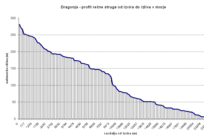
Gradient profile of the Dragonja River (author: Boštjan Burger, 2006)
The longitudinal profile has not yet reached an "ideal" balanced gradient. Significant deviations are observed in the upper-middle section (at altitudes between 90m and 150m), where strong riparian erosion occurs alongside the trapping of the bed in sandstone slabs, which limits vertical erosion.