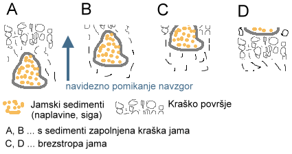
The term roofless cave (brezstropa jama) is a karst term introduced into karst and geomorphological terminology by the Slovenian karstologist Andrej Mihevc from the Institute for Karst Research in Postojna. A roofless cave is a cave opened by the process of denudation and is usually filled with sediments, which are usually the oldest preserved on the karst. Karst forms (caves, abysses) deep below the surface, due to denudation and isostasis, seemingly move towards the surface until the stop is removed and they become a surface karst phenomenon.
Before studying Andrej Mihevec, karstologists replaced the roofless caves formed in the leveled karst surface, under which there were horizontal cave tunnels, with dry valleys and used them to support hypotheses about the pre-karst fluvial phase of karst surface development. The roofless cave can also be recognized by its flattened, non-karst bottom and distinctly karst surroundings.
When documenting the roofless cave near Rakov Škocjan, he also documented and described an interesting phenomenon of horizontal depressions.

Description of the roofless cave near Rakov Škocjan:
The studied roofless cave runs in the direction of azimuth 354° degrees from the gable to the macadam road Rakov Škocjan-Postojna gate at Podbojev laz in the length of 265 m. The gabled part is Y-shaped, in which overgrown screes run towards the bottom of the roofless cave. Overgrown scree tells of the slow process of weathering fireplaces at the edge of the roofless cave, which is largely caused by the mechanical action of tree roots. Indic for this hypothesis is the recent collapse of the edge part in the "third" part of the roofless cave.
The edges or walls of the first hall are cut off, with the eastern edge slightly higher than the western one. Microcorrosion phenomena are visible on the wall of both: a rough wall. At the bottom of the hall grow tall spruces, and the undergrowth grows on a non-rocky base that has a deep homogeneous horizon, of indefinable depth, indicating that the bottom is covered with alluvium. The first hall ends with a pronounced stone landslide on the right, eastern edge with a slight rise of the passage to the second hall.
The passage between the first and second halls is on the right edge. The walls of the western edge are partly overhanging and smaller subsurfaces appear, which are of erosive origin. The second hall is smaller, funnel-shaped and in the direction of the ceilingless cave closed with a sharp edge, but in the whole course towards the bottom covered with a stone collapse in the form of scree towards the very narrow non-stone bottom.
The exit from the second smaller hall is surrounded on the eastern edge by large moss-covered rocks formed by selective corrosion and erosive action of the forest (tree roots and vegetation). The western edge has smaller landslides. The second hall then goes into a longer leveling. The leveling is a heavily denuded tunnel with a flat bottom and a shallow edge indicated by rocks scattered at a small angle. The rocks are the result of selective corrosion and the lower edge indicates the rise of the former cave tunnel. The tunnel passes into a larger leveling, where suffusion sinkholes are lined up in the direction of the continuation of the first part of the roofless cave (first + second hall + tunnel). The sinkholes are deep and indicate underground removal of material, probably alluvium. The direction of drift is not clear and the depth and structure of the alluvium could be indicated by an image obtained with "georadar". 400 m to the west, a new roofless cave runs almost parallel, but the connection with the part described above is not understandable.
