
Lake Bohinj – the natural, geological and cultural character of Slovenia’s largest lake
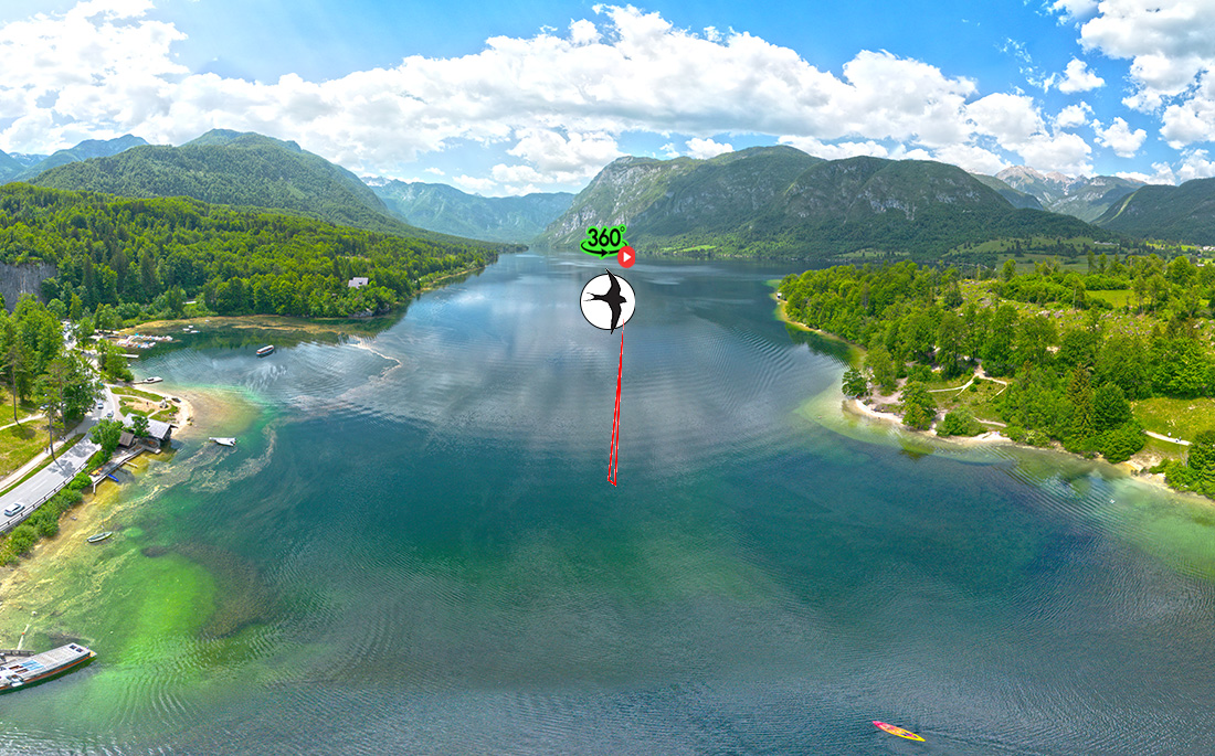
Lake Bohinj is the largest permanent natural lake in Slovenia and one of the most characteristic glacial landscapes of the Julian Alps. It lies at an elevation of approximately 525 m in an elongated basin between the northern slopes of Pršivec and the southern ridge of the Lower Bohinj Mountains. The lake is 4350 m long, up to 1250 m wide, and reaches a maximum depth of 45 m. Its surface area covers 318 ha, while the shoreline measures 10,900 m, reflecting a relatively simple yet distinctly glacial morphology.
Geographical setting
The lake lies in the central part of the Bohinj Basin, bordered to the north by the steep slopes of Pršivec and the Fužine Alpine pastures, and to the south by the forested ridges of Vogel and Komna. To the east, the basin opens towards Stara Fužina and Ribčev Laz, while to the west it narrows into the glacially carved trough of Ukanc. The entire area is part of the Triglav National Park, ensuring a high level of landscape and ecological preservation.
From the surrounding peaks, especially the cliffs of Mirnjak (1540 m), the full glacial structure becomes visible: the elongated basin, prominent moraines, steep valley sides and the wide, sediment-filled floor of the Bohinj Basin.
Morphology and origin
Lake Bohinj is of glacial–tectonic origin. An initial tectonic depression was reshaped during the Pleistocene by the extensive Bohinj Glacier, which at the peak of the last glacial maximum was several hundred metres thick. The glacier:
-
carved out the lake basin,
-
deposited prominent terminal moraines at the eastern end,
-
formed the lake’s characteristic elongated shape,
-
filled the western part of the basin with sediments, making that section shallower.
At the end of the last Ice Age, the lake level was around 16 m higher than today. The lake extended as far as present-day Stara Fužina, as evidenced by fossil lake terraces on the slopes above the village.
Hydrology
The main surface inflow is the Savica, which descends from the waterfall, cuts through a belt of morainic material and enters the lake at Ukanc. Lake Bohinj is distinctly outflowing: its waters drain through the Jezernica, which after less than 100 m joins the Mostnica to form the Sava Bohinjka.
A special feature of the northern shore is a series of karst springs that supplement the lake’s water. The most notable among them is Govic, a striking karst abyss in the cliff below Pršivec. Govic is not an underwater spring; water flows from it only during periods of high water, when the underground system becomes saturated and overflows through the opening above the lake.
Historical development
Early settlement
The Bohinj Basin was inhabited already in prehistory, though the immediate lakeshore was less suitable for permanent settlement due to marshy conditions and fluctuating water levels. Villages developed mainly on higher terraces (Stara Fužina, Studor, Srednja vas), while the lakeshore remained sparsely populated.
The First World War
Although Bohinj was not directly on the front line, it played an important logistical role. The Bohinj Railway served as a key connection towards the Soča Front, and local inhabitants were involved in transport, supply and the construction of military infrastructure. Smaller military units were stationed in the area to control communication routes and transport lines.
Tourism development
Tourism in Bohinj began to flourish in the 19th century, when the area became a popular destination for domestic and foreign visitors. Key milestones include:
-
1890–1910: development of mountaineering; construction of mountain huts on Vogel, Komna and in the Valley of the Triglav Lakes.
-
1906: opening of the Bohinj Railway, linking the region with Central Europe and Trieste.
-
Early 20th century: establishment of the first hotels and bathing areas along the lake.
-
Post–Second World War: expansion of tourist infrastructure, construction of campsites, ski lifts on Vogel and organised bathing areas.
-
1981: inclusion of the lake within the Triglav National Park, directing development towards sustainable and nature-friendly use.
Present-day situation
Today, Lake Bohinj is one of Slovenia’s most important natural areas, characterised by:
-
a high degree of ecological preservation,
-
carefully regulated tourist use,
-
a strong emphasis on sustainable management.
The lake allows swimming, rowing, kayaking, SUP, diving and fishing – all under controlled conditions. Motorboats are prohibited; only electric vessels are permitted. The shoreline remains largely undeveloped, preserving the lake’s pristine Alpine character.
Bohinj is also a major starting point for numerous mountain routes (Vogel, Komna, Pršivec, the Fužine pastures) and forms an essential part of the identity of the Triglav National Park.
Interestingly, the level of the lake was 16 m higher at the end of the last ice age, and at that time the lake reached the present-day settlement of Stara Fužina, as indicated by the local fossil lake terraces. Bohinj Lake was included in the Triglav National Park area in 1981. A beautiful view of the lake is from the peak of the Mirnjak cliffs (1540m).
Literature: Firbas P., 2001. All Slovenian Lakes: Lexicon of Slovenian Standing Waters, Delo, pp. 84-88; Kunaver J., 1999. Slovenia - Landscape and People, Mladinska knjiga, p. 60; Sketch of the lake: photograph of the TNP information board, February 2004.