

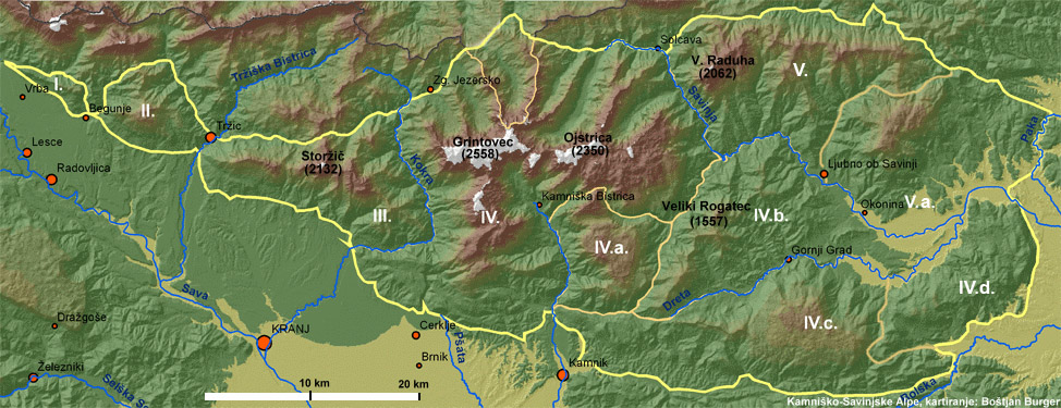
Kamniško-Savinjske Alpe (area of 988 km²). Mountain range in northern Slovenia.
The Area of the Kamnik–Savinja Alps
The Kamnik–Savinja Alps are a mountain range in northern Slovenia, extending partly into Austria. They cover approximately 988 km², most of it within Slovenia. This is the country’s second-highest mountain range after the Julian Alps, with peaks rising above 2500 m. The highest summit is Grintovec (2558 m). The range belongs to the Southern Limestone Alps and is characterized by glacially carved valleys (Logar Valley, Kamniška Bistrica, Matkov kot, Robanov kot), numerous waterfalls, and rugged karst plateaus.
About 75% of the area is forested, while the summits are bare and rocky. To the east, the Alps connect with the Karawanks, while to the south they descend toward the Ljubljana Basin. Hydrology plays a crucial role in shaping the internal division of the range: rivers and streams such as the Savinja, Kokra, and Kamniška Bistrica form natural boundaries between its sections.
The division into five groups was proposed in the early 2000s by Boštjan Burger as an attempt at regionalization based on hydrological systems.
I. Western Section (Moste – Smokuški vrh)
The westernmost part begins at the confluence of the Završnica and the Sava Dolinka near Moste. It extends as a narrow ridge from Brinjevo vrh (715 m) north of Žirovnica to Smokuški vrh (868 m), then toward Kališče (980 m) and along the Blatnica stream to Begunje.
II. The Dobrča Group
This section stretches from Begunje along the Begunjščica stream valley, across Luknja to Prevala (1311 m), then south of Potočnik’s ravine to the Mošenik valley and the confluence of Mošenik with the Tržič Bistrica.
III. The Storžič Group
It extends from the ridge of Kriška Gora and Tolsti vrh (1715 m) to Javorniški preval (1467 m), continuing along the Tržič ravine to the Reka stream. The highest peak here is Storžič (2132 m).
IV. Central Section – The Grintovec Group
This part begins along the Kokra and Jezernica rivers and includes the area of Jezersko, Ravenska Kočna, and Jenkova planina. It encompasses the ridge of Mala Baba (2018 m), Velika Baba (2127 m), and Ledinski vrh (2108 m), continuing to Jezersko Saddle (2036 m), Okrešelj, and Kamniško Saddle (1876 m). The highest peak is Grintovec (2558 m), also the highest in the entire Kamnik–Savinja Alps. Here converge the valleys of Belska Kočna, Matkov kot, and Logar Valley. To the northeast, the chain continues with Mrzla gora (2203 m), Matkove kope (1957 m), and Pavlič’s Walls (1653 m). Between Matkov kot and Logar Valley lies another chain with Zabrložnica (1635 m), Veliki vrh (1539 m), and Orlovec (1251 m). A key hydrological axis is the Savinja River, which originates here and is the longest river entirely within Slovenia.
V. Eastern Section – Raduha and the Smrekovec Range
This section begins at the Savinja tributary Klobaša, beneath Grohat pasture (1367 m), north of the Raduha ridge. It continues toward Spodnje Sleme (1254 m), along the Bistra stream to Vrtačnik’s stream, then under the northern slopes of the Smrekovec range across Ludranski vrh to Koroška Kramarice. The boundary follows the Kramarica stream to the source of the Ljubija, beneath Visočki vrh to the Šentflojanščica stream, and onward to its confluence with the Paka River. To the east, the area ends beneath the Dobrovelje plateau west of Braslovče, south of Menina planina and the Tunjiško hills, where the Alps descend toward the Ljubljana Basin.
The Kamnik–Savinja Alps are a highly diverse mountain range whose structure is defined not only by geology but also by hydrology. The river systems naturally divide the area into five groups, a framework that Boštjan Burger used in the early 2000s as the basis for a hydrology-driven regionalization. This division provides deeper insight into the natural dynamics of the region and serves as a valuable foundation for geographical, touristic, and conservation studies.