 aerial

The Ledava River is a watercourse in northeastern Slovenia. Its length from the source near the village of Pichla in Austria to its confluence with the Mura River at the Slovenian–Croatian–Hungarian tripoint is 76 kilometres. Although not a large river, its influence on the landscape, natural processes, and human settlement is remarkable. Ledava links the hilly region of Goričko with the flatlands of Prekmurje, passes through diverse geological structures, shapes varied ecosystems, and has significantly influenced the development of settlements throughout history. Its story is one of interaction between nature and people, of a watercourse that is both calm and dynamic, and of a landscape that has evolved along its banks over centuries.
Source and Upper Course: Goričko – A Stream in a Varied Relief
Ledava rises in the northern part of Goričko, near the settlement of Pertoča, where it forms as a small stream among rolling hills, forest edges, and scattered farms. Goričko is a characteristic hilly region composed of impermeable rocks such as marl, clay sediments, and sandstone. This geological structure enables rapid surface runoff, which means the river responds quickly to rainfall.
In its upper course, Ledava is:
-
narrow and stream-like,
-
fast-flowing, descending through a varied relief,
-
marked by erosional processes that shape gullies, small ravines, and steep banks,
-
hydrologically dependent on precipitation, with rapid fluctuations in discharge.
During dry periods, the flow can decrease significantly, while heavy rainfall causes quick rises in water levels. This responsiveness is typical of watercourses in hilly regions with impermeable geological substrates.
The upper course of Ledava also functions as an important ecological corridor, connecting forest habitats across Goričko. Wet meadows, forest edges, and small marshy areas along the river provide habitats for amphibians, birds, and numerous invertebrates.
Ledavsko jezero (Ledava Lake)
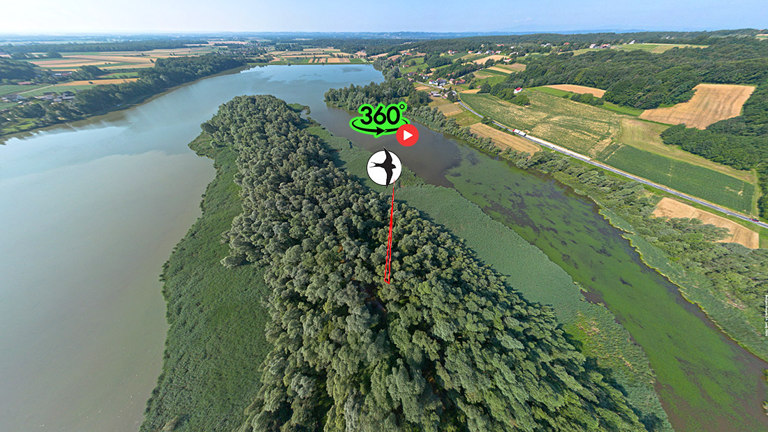
Ledavsko jezero near Krašči is the largest retention reservoir in Prekmurje and one of the most important hydraulic engineering structures in the Ledava basin. Although artificial, it has developed over decades into a rich natural ecosystem that combines flood protection, ecological value, and recreational significance. Its story reflects a blend of technical expertise, natural processes, and local life.
Historical development of Ledavsko jezero
Historically, Ledava was highly prone to flooding. Its rapid response to rainfall in the upper course and wide floodplains in the lower part often threatened agricultural land and settlements, especially around Cankova, Murska Sobota, and Beltinci. Floods were most frequent in autumn and spring, when prolonged rainfall or snowmelt caused sudden rises in water levels.
In the second half of the 20th century, a decision was made to construct a retention reservoir to control high waters. The location near Krašči was chosen due to its suitable terrain, natural depression, and the possibility of forming a large water surface with relatively minimal intervention.
Construction proceeded in several phases:
-
regulation of the Ledava riverbed and preparation of the terrain,
-
construction of the dam and outlet structures,
-
formation of the retention basin,
-
reinforcement of the banks and planting of vegetation,
-
establishment of a monitoring system for flow management.
Once completed, the lake became a key element of regional flood protection. Over time, it evolved from a hydraulic structure into a natural habitat and recreational area.
Size, shape, and volume
Ledavsko jezero is the largest standing water body in Prekmurje. Its main characteristics include:
-
Surface area: approximately 60 hectares (depending on water level)
-
Length: around 2 kilometers
-
Width: between 200 and 600 meters
-
Volume: several hundred thousand cubic meters of water
-
Depth: average 2–4 meters, with deepest areas exceeding 6 meters
The lake’s irregular shape reflects the natural terrain and the method of damming. Its banks are partly reinforced and partly natural, allowing diverse habitats to flourish.
Detailed hydraulic engineering analysis
Ledavsko jezero is designed as a high-water retention reservoir, meaning its primary function is regulating flows in the lower course of Ledava. Key hydraulic engineering features include:
Dam and outlet system
-
The dam is earthen, reinforced with a clay core to prevent seepage.
-
The outlet system enables precise flow regulation, essential for flood prevention.
-
During high water, outlets close to retain water in the lake.
-
During normal flows, outlets open to maintain a stable water regime.
Hydraulic effects
-
The lake acts as a buffer, reducing extreme hydrological fluctuations.
-
It slows water velocity in the lower course, reducing erosion.
-
It raises local groundwater levels, benefiting agriculture and wetlands.
Influence on the basin
-
Stabilizes flows in the middle and lower course of Ledava.
-
Reduces flood risk in downstream settlements.
-
Improves water resource management during dry periods.
Ecosystems of Ledavsko jezero
Despite being artificial, Ledavsko jezero has become one of the most important natural habitats in Goričko. Numerous ecosystems have developed, supporting high biodiversity.
Water birds
The lake is an important stopover for migratory birds, including:
-
herons
-
grebes
-
various duck species
-
gulls
-
kingfishers
Fish
The lake hosts many fish species:
-
carp
-
catfish
-
pike
-
bream
-
roach
Amphibians and insects
Shallow areas and wetlands along the banks are home to:
-
frogs
-
newts
-
dragonflies
-
aquatic beetles
Vegetation
Plants around the lake include:
-
reeds
-
sedges
-
aquatic macrophytes
-
riparian trees and shrubs
This vegetation stabilizes the banks, reduces erosion, and creates habitats for wildlife.
Recreation and social significance
Today, Ledavsko jezero is an important recreational area that attracts both locals and visitors.
Recreational activities
-
Fishing: one of the most popular fishing spots in Prekmurje
-
Walking and hiking: maintained paths around the lake
-
Birdwatching: rich fauna attracts nature enthusiasts
-
Photography: peaceful surroundings and diverse nature
-
Cycling: connected to Goričko’s cycling routes
Social significance
-
The lake is part of local identity
-
It provides a space for relaxation and community gatherings
Lower Course: A Lowland River Between the Mura and Goričko
The lower course of the Ledava River is distinctly lowland, slow-flowing, and heavily reshaped by both natural processes and human intervention. From the outflow of the Ledava Reservoir to its confluence with the Mura, the river runs across a broad, largely reclaimed plain, where the channel is almost entirely artificially regulated. The natural features of the former meandering river survive only in small remnants of riparian vegetation and occasional deposits of driftwood that create slight bends during periods of low water.
Parallel Course with the Mura
One of the most striking characteristics of the lower Ledava is that it flows almost parallel to the Mura River for more than 50 kilometres. This unusual pattern is the result of extensive sediment deposition by the Mura during the last Ice Age, when the river accumulated large quantities of gravel, sand, and silt. These deposits raised and widened the Mura’s floodplain, effectively pushing the Ledava northwards, against the foothills of the Goričko region. As a result, Ledava was forced to follow the edge of the alluvial plain rather than flowing directly toward the Mura.
Asymmetrical Drainage Basin
The lower Ledava has a distinctly asymmetrical catchment:
-
From the right (the Mura plain), it receives almost no tributaries because the terrain is elevated and composed of Mura’s alluvial deposits; only Črnec and Kopica enter from this side.
-
From the left (the slopes of Goričko), numerous streams flow into Ledava: Grački, Brezovski, Mačkovski, Martjanski, Lipnica, Kobiljski potok, and just before the confluence, Velika Krka.
This asymmetry reflects the geomorphological evolution of the plain between the Mura and Goričko.
Floodplain and Wetland Areas
The lower course of Ledava crosses several extensive wetland zones:
-
Črni log – a lowland forest on the alluvial plain,
-
Murska šuma – a forested wetland between Ledava and the Mura,
-
Dobrovniški log and Hraščica – important floodplain forests.
These areas are part of the Natura 2000 network, providing key habitats for species such as the black stork, middle spotted woodpecker, collared flycatcher, and many others.
Confluence with the Mura
Near the village of Pince, Ledava turns southeast and forms the state border with Hungary at Slovenia’s easternmost point. Just before entering the Mura, it receives its largest tributary, Velika Krka, and then flows into the Mura River. Hydrologically, Ledava is longer and larger than Krka, and official data therefore classify Ledava as the main watercourse, despite some older sources suggesting otherwise.
Historical Transformation of the Ledava River Channel
Ledava is one of the most heavily modified rivers in Slovenia. Its present form is the result of more than 170 years of interventions that gradually transformed a naturally meandering river into an artificial drainage channel.
1. Early Regulation in the 19th Century
The earliest major interventions date to the period of the Kingdom of Hungary, around 1850, when:
-
Ledava was redirected into an artificial channel from Murska Sobota to Krka,
-
the channel was straightened to reduce flooding,
-
extensive drainage and land reclamation began on the floodplain.
It is possible that during this period Ledava was also diverted into the Krka, which explains certain historical maps and descriptions.
2. Early 20th Century – Organized Water Management
In 1901, the High Water Drainage Society was established in Lendava. It was responsible for:
-
maintaining the channel,
-
managing tributaries,
-
draining marshy areas.
In 1907, the society obtained permission for large-scale river works, but the First World War interrupted the project.
3. The Relief Channel (1948–1958)
After the Second World War, a 7.6‑kilometre relief channel was constructed, connecting Ledava directly to the Mura. This channel diverts excess water during high flows and was a key measure to reduce flood risk in Murska Sobota.
4. Reservoirs (1970–1985)
In the second half of the 20th century, several major reservoirs were built:
-
Ledava Reservoir (1978) – 5.6 million m³, reducing flood peaks,
-
Radmožanci dry reservoir (1980–1983) – 6.3 million m³,
-
channel improvements between Rakičan and Renkovci (completed in 1985).
These interventions significantly altered the hydrological regime and reduced flood risk, although complete protection is not possible.
5. Present State – An Artificial Drainage Channel
Today, Ledava is:
-
almost entirely regulated,
-
shaped into a trapezoidal cross-section,
-
with limited riparian vegetation,
-
ecologically degraded due to pollution and altered morphology.
Nevertheless, natural processes are slowly reintroducing variability, as the river begins to form slight bends and deposits during periods of low water.
The lower course of the Ledava River is a remarkable example of a watercourse shaped first by major natural geomorphological forces and later by extensive human intervention. Despite its regulated form, the floodplain forests, wetlands, and riparian habitats preserve a surprising richness of biodiversity, giving the lower Ledava significant ecological and conservation value.
People, settlements, and historical development
The Ledava River has shaped human life in the Goričko and Prekmurje regions for centuries. Although modest in size, its role in settlement, local economy, and cultural landscape has been significant. Villages and towns developed along its banks, relying on the river as a source of water, fertile land, and natural routes connecting the hilly and lowland environments.
Settlements along the Ledava: From Source to Confluence
Goričko – Dispersed Settlement and Agricultural Tradition
In the upper course of the Ledava, settlements such as Pertoča, Rogašovci, Krašči, and numerous smaller villages emerged among the hills. Here, the river served primarily as:
-
a source of drinking water,
-
a watering place for livestock,
-
a natural boundary between land parcels,
-
a foundation for mills and small craft activities.
Goričko has traditionally been an area of mixed agricultural use, where meadows, fields, orchards, and forests form a mosaic landscape. In this region, where water sources are relatively scarce, Ledava was an essential element of everyday survival.
Prekmurje – Compact Villages and Economic Growth
Upon entering the plain, Ledava flows past larger settlements such as Cankova, Murska Sobota, and Beltinci, as well as numerous villages that developed along its floodplains. In this part of its course, the river enabled:
-
the expansion of extensive agricultural land,
-
drainage and reclamation of wet areas,
-
the construction of mills, which were economic hubs of local communities,
-
the development of trade routes that followed natural corridors between Goričko and the Mura River.
Murska Sobota, the largest town along Ledava, grew precisely because of its favourable position between two distinct landscapes and its access to water. The river supported early craftsmanship and later industrial facilities that required water for cooling and technological processes.
Ledava as an Economic Axis: Milling, Agriculture, Crafts
Milling
Historically, several mills operated along the Ledava, especially in its middle and lower course. They were:
-
centres of local economic activity,
-
places of social interaction and exchange,
-
essential for grain processing in a region dominated by agriculture.
Milling declined in the 20th century due to river regulation, changes in water regime, and industrialisation.
Agriculture
Ledava enabled the development of:
-
floodplain meadows, known for their exceptional fertility,
-
irrigation systems, especially after the construction of the reservoir,
-
large arable fields, which today define the landscape of Prekmurje.
Agricultural use was closely tied to the river’s hydrological regime: floods enriched the soil with nutrients, while dry periods required irrigation.
Crafts and Local Activities
Various small-scale activities developed along the river, including:
-
sawmills,
-
blacksmith workshops,
-
small facilities for processing wood and agricultural products.
All these activities depended on a reliable water source.
Historical Development: From a Natural River to a Regulated Watercourse
Before the 19th Century – A Natural, Meandering River
Ledava was once a strongly meandering river, shaping wide floodplains. Settlements developed on slightly elevated terraces where flood risk was lower.
19th Century – First Regulations
During the period of the Kingdom of Hungary, extensive regulation began:
-
straightening of the river channel,
-
drainage of floodplain areas,
-
redirecting the flow in certain sections.
The goal was to increase agricultural productivity and reduce flooding.
20th Century – Reservoirs and Relief Channels
In the second half of the 20th century, Ledava underwent its most significant transformations:
-
construction of the Ledava Reservoir (1978),
-
construction of the Ledava–Mura relief channel (1948–1958),
-
channel improvements between Rakičan and Renkovci,
-
construction of the Radmožanci dry reservoir.
These interventions reduced flood risk but altered the natural water regime and river morphology.
Today – Between Nature and Human Influence
Despite regulation, Ledava has preserved many natural features:
-
wetlands,
-
floodplain forests,
-
riparian vegetation,
-
rich bird and amphibian fauna.
This interplay between natural and human-shaped elements gives Ledava a distinct identity.
Ledava Today: A Natural, Recreational, and Cultural Space
Today, Ledava is valued primarily as:
-
a recreational area (walking and cycling paths),
-
a fishing site rich in fish species,
-
a natural habitat attracting birdwatchers,
-
a cultural landscape that connects nature and human history.
Along the Ledava, a sense of continuity remains: a river that once ensured survival now provides a space for nature appreciation and understanding the historical development of the region.