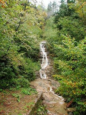
Desni pritok Zale
| Lokacija / Location: | Idrijsko (ob cesti Godovič-Idrija) |
| GPS: | N: 45°58'24" E: 14°03'29" |
| Nadmorska višina: | ~ 412 m |
| Višina slapišča: | ~ 12 m (37') |
Tri kilometre pred sotočjem z reko Idrijco priteka v Zalo potoček, ki tik pred magistralno cesto Godovič-Idrija (v bližini cestne oznake "6.5 km") ustvarja dokaj zanimivo slapišče.
Zanimivo je, da je pretok vode stalen in v sušnih obdobjih včasih celo večji kot od rečice Zale. Dostop do slapišča je lahek, vendar je zaradi neposredne bližine ceste potrebna previdnost zaradi cestnega prometa.
About 3 km before the confluence with the Idrijca River, the Zala river receives a tributary with a permanent water flow and a 12 m high waterfall. Access is near the road mark "6.5 km" on the Godovič-Idrija road. Access is easy, but the road traffic can be risky.
