| Stream | Brčin stream |
| Main waterfall | Sapet (60 m / 197 ft) |
| Total height | 300 - 400 m (multi-level system) |
| Location | Učja Canyon, Žaga (Bovec) |
On the way to border crossing Učja on the right side of the river Učja and the canyon with the same name, after the second sharp curve (1 km from the village Žaga), we can see a ravine sweeping between Skutnik (1720 m) and Mala Baba (1977 m). In autumn and spring, the whiteness of water falling in waterfalls towards the river Učja can be seen. In summer, rich greenness covers the view to the beautiful system of waterfalls and only the highest ones whiten under the greenness.
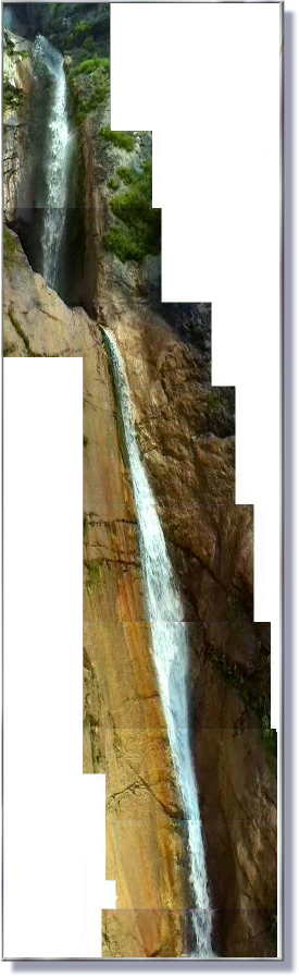
Waterfall Sapet (Click for enlargement)
A really beautiful combination of white falling water over reddish rocky mass and rich greenness. A look to a special map tells us that water which creates these beautiful waterfalls is called stream Brčin, although domestic people don't know this name. They know only the highest, multi level composed waterfall (60 m) calling it Sapet (also general name for waterfall). One of the local people told, that the entire system of waterfalls was called Globišča.
Access
The Ravine of Globisca is located near the great (and worth seeing) canyon of Učja. South of Bovec (North-Western Slovenia - Posočje - Soča river region).
Starting point: ŽAGA. From the bridge in Žaga, take the path above the canyon on the left side. The path soon turns into a well-made "mulatjera" (mule track), leading (15 min walk) to a large pasture. From there, follow the edge of the pasture to a descent that leads to the foot of the main waterfall. Total walk: 30 minutes from Žaga.