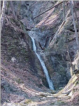
Located in the upper part of the Podvolovljek valley at St. Anton. Above the settlement is the meadow of Selišnik. Below the meadow is a ravine with the same name: Selišnikov graben. From the Selišnik farm, a path leads to the ravine where an interesting cliff with a small cave can be found.
| Overall Height: | 35 meters (115 ft) |
| Tallest Drop: | 7 meters (22 ft) |
| Total Drops: | 4 |
| Waterfall Type: | segmented waterfall |
| Location (GPS): | N:46°18'29" E:14°42'30" |
| Altitude (bottom): | ~ 974 metres (2500 ft) |
| Best Flows: | spring, after rainfall |
The ravine ends with a kettle-shaped formation and cliffs around are very picturesque. It is worth seeing for experienced hikers, although there is no formal path forward from the cliff area.