Map of Croatia – overview of regions and coastline
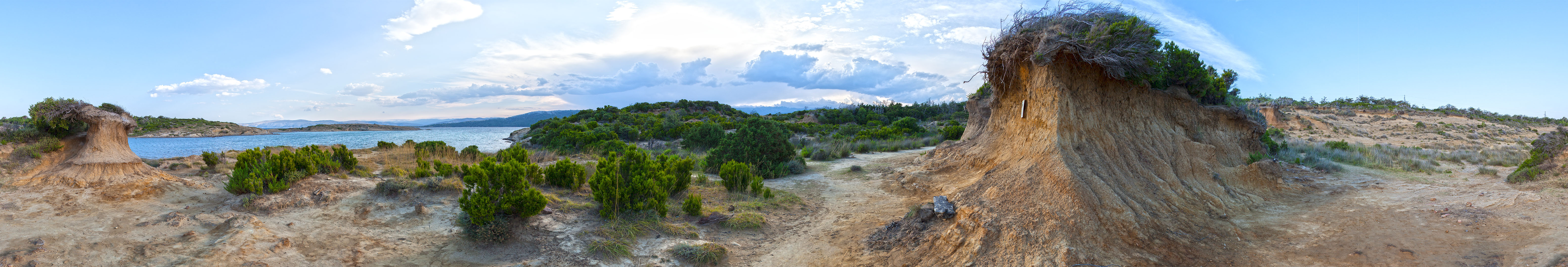
Geo park Rab
Geo park Rab is located in the Lopar region on the northern part of Rab Island. The area is known for its sandy bays, geological formations, and rich natural heritage. The virtual excursion offers interpretive points where natural and cultural elements intertwine.
Croatia is a Central European and Mediterranean country stretching between the Pannonian Plain, the Dinaric Alps, and the Adriatic Sea. Its physical geography is remarkably diverse, combining lowlands, plateaus, mountains, karst phenomena, and a deeply indented coastline with over a thousand islands.
Pannonian Plain
The eastern part of Croatia lies along the Drava, Sava, and Danube rivers. This fertile lowland is composed of alluvial sediments, ideal for agriculture. Geologically, it belongs to the younger Tertiary deposits of the Pannonian Basin. The region features floodplains, oxbow lakes, wetlands, and thermal springs.
Dinaric Alps
Central and southwestern Croatia is part of the Dinaric mountain system. Formed mainly of limestone and dolomite, it hosts classic karst features: sinkholes, poljes, caves, and disappearing rivers. The highest peak is Dinara (1,830 m). The Plitvice Lakes National Park is a globally recognized example of karst hydrology.
Adriatic Coast and Islands
Croatia’s coastline stretches 5,835 km, including 1,777 km of mainland and 4,058 km of island shores. With over 1,200 islands, the largest are Krk and Cres. The coast is highly indented, featuring bays, peninsulas, and natural harbors. Mediterranean vegetation, terraced agriculture, and dry-stone walls are typical.
Hydrography
Major rivers include the Sava, Drava, Kupa, Neretva, and Cetina. Rivers in the Pannonian region are slow and meandering, suitable for navigation. In contrast, rivers in the Dinaric region are fast, steep, and ideal for hydropower. The Adriatic Sea is shallow, warm, and saline.
Mediterranean – mild winters, hot dry summers (Dalmatia, Istria)
Climate strongly influences vegetation, settlement patterns, and land use.
Geological Structure
Croatia lies at the junction of the Eurasian and Adriatic microplates. Earthquake-prone zones exist, especially in Dalmatia and around Zagreb. Geological formations range from Paleozoic metamorphic rocks to Neogene sediments.
Croatia’s physical geography underpins its cultural diversity, historical development, and touristic appeal. From karst plateaus to coastal islands, from Pannonian plains to Dinaric peaks — Croatia offers a rich natural mosaic worth presenting in a visually engaging, accessible, and archival-quality digital environment.
Regions of Croatia
Croatia is traditionally divided into several cultural and geographic regions, each with its own landscape, heritage, and character. These regions are not administrative units, but they reflect historical, natural, and cultural identities.
Istria – coastal peninsula with Roman and Venetian heritage, olive groves, and hilltop towns
Kvarner – gateway between Istria and Dalmatia, includes islands like Krk, Cres, Lošinj, and Rab
Dalmatia – stretches from Zadar to Dubrovnik, known for islands, medieval towns, and national parks
Slavonia – eastern plains along the Drava, Sava, and Danube rivers, rich in agriculture and folklore
Baranja – fertile region north of the Drava, shared with Hungary, known for wine and wetlands
Srijem – southeastern corner near Vukovar, with Roman and Austro-Hungarian influences
Gorski kotar – forested highlands between Karlovac and Rijeka, ideal for hiking and winter retreats
Lika – karst plateau with Plitvice Lakes and rugged terrain
Zagorje – hilly region north of Zagreb, dotted with castles and thermal springs
Međimurje – northernmost region between Mura and Drava rivers, known for vineyards and folklore
Podravina – along the Drava River, with cultural ties to northern Croatia and Hungary
Posavina – lowlands along the Sava River, historically important for trade and settlement
Banovina (Banija) – central inland region with wartime history and rural landscapes